It looks shooped, but I can't tell for sure. Any thoughts?
Satellites : general discussion and musings
Re: Satellites : general discussion and musings
"Satellite Shows Guatemala Volcano Erupting"
It looks shooped, but I can't tell for sure. Any thoughts?
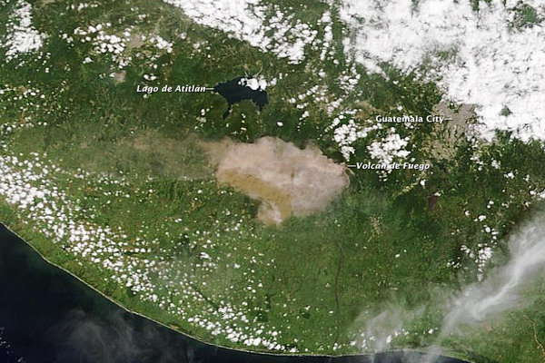

It looks shooped, but I can't tell for sure. Any thoughts?
Re: Satellites : general discussion and musings
Yes the ELA indicates shooping, especially the alleged volcanic region and Lado de Atitlan region.
Source of the original pic? Caption should have read "Artist's imagination"
Source of the original pic? Caption should have read "Artist's imagination"
-
reichstag fireman
- Member
- Posts: 465
- Joined: Wed May 16, 2012 1:09 am
Re: Satellites : general discussion and musings
You got several answers to your questions about the magnitude of reflected light from an "artificial satellite". And links to two scientific papers. Neither of which (to my layman's understanding) has any credibility.CitronBleu wrote:Question asked. I'll wait for answers.simonshack wrote:how do (amateur) astronomers go about making the distinction between NEA's and artificial satellites?
http://stargazerslounge.com/topic/16153 ... satellite/
The first paper was apparently published in 1970 by Rockwell, a corporation heavily invested in the phony "space industry". According to wonkypedia, (before the Teledyne takeover), Rockwell had sales of $27 billion annually. Though God knows what the gangsters claimed to be selling and which fools were buying it? Can only be gummints.
The most glaring problem with the Rockwell paper is that they didn't even identify the "satellites" they claimed to be measuring for light reflection. Identifications were by meaningless numbers, e.g. "Satellite #231". Conveniently, leaving no means for verifying any of the supposed measurements. And surely, as a poster pointed out in the Stargazers' Lounge forum, the size of an orbiting object is critical to any light reflection measurement. A larger object reflects more light. Yet Rockwell didn't even both to consider "satellite" size in their (totally bogus) calculations. In conclusion (i) the Rockwell paper should be hanging from a nail on the lavatory wall, and (ii) the Rockwell Corporation, a $27bn swindle is thankfully no more.
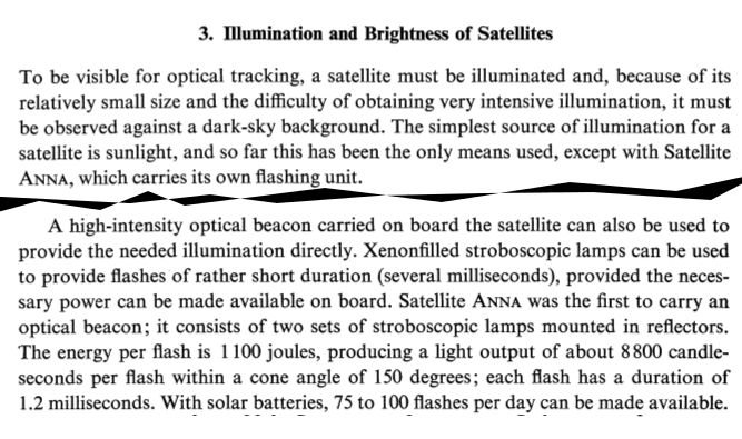
The second paper was reportedly published in 1963 by "scientist George Veis" (real perp?) from the Smithsonian Astrophysical Observatory. NASA hosts the document today, and by definition it must be 100% garbage. I especially enjoyed 'George's claim that at least one "artificial satellite" (called "ANNA") orbits with flashing strobe lights on it. Just the one strobing satellite? No more launched since 1963? Why's that? Conveniently, for those trying to maintain the credibility of this particular hoax, ANNA's strobe pulse reportedly happens very infrequently (just a few dozen flashes a day), which are all very brief (1.2 milliseconds). Blink and you miss it. Fancy that!
On that same Stargazers' forum (are all these "amateur astronomy" forums run by perps?), there was one vaguely useful suggestion (in relation to another question). Readers were pointed towards the 800+ old astronomy books to be found on the Internet Archive. Many of these books date back to the Victorian era and before. These books were authored by men yet to be poisoned by NASA and other witting wreckers of the whole body science. Perhaps hidden amongst that mountain of mouldy digital paper, are some treasures with genuine observations of the "minor planets" (aka "asteroids").
Re: Satellites : general discussion and musings
Earth-Sun Distance Measurement Redefined
Under the new definition, the astronomical unit (or AU) — the measurement used for the Earth-sun distance — is no longer always in flux, depending on the length of a day and other changing factors. It is now a fixed number: 149,597,870,700 meters, which is the equivalent of almost 92.956 million miles.
Klioner explained the simpler definition is helpful, for instance, for scientists who formulate ephemerides — tables that give the precise position of astronomical objects in the sky. They utilize the astronomical unit to calculate the motion of bodies in the solar system. [Solar System Explained From the Inside Out (Infographic)]
...
At the same time, the redefinition can serves an epitaph to the bygone era when Earth-bound scientists depended on viewing angles to calculate celestial distances.
Lacking precise instrumentation, early astronomers relied heavily on angles to calculate the size of the universe. By studying Mars from two separate points on Earth, 17th-century Italian astronomer Giovanni Cassini was able to use trigonometry to calculate the distance from Earth to the sun with only about a 6 percent error.
"Expressing distances in the astronomical unit allowed astronomers to overcome the difficulty of measuring distances in some physical unit," Capitaine told SPACE.com by email. "Such a practice was useful for many years, because astronomers were not able to make distance measurements in the solar system as precisely as they could measure angles."
Modern instruments can come within a few meters of exactly determining distances of over 150 million meters, or some 93,000 miles.
The astronomical unit eventually came to be defined by a mathematical expression that involved the mass of the sun, the length of a day, and a fixed number known as the Gaussian gravitational constant. Because the Earth orbits its star in an ellipse rather than a circle, the length of a day shifts over the course of a year. At the same time, the sun is constantly transforming mass into energy.
http://news.yahoo.com/earth-sun-distanc ... 36036.html
-
whatsgoingon
- DELETED THEIR OWN POSTS :(
- Posts: 576
- Joined: Thu Oct 13, 2011 7:56 pm
Re: Satellites : general discussion and musings
a
Last edited by whatsgoingon on Fri May 24, 2013 10:31 am, edited 1 time in total.
-
reichstag fireman
- Member
- Posts: 465
- Joined: Wed May 16, 2012 1:09 am
Re: Satellites : general discussion and musings
whatsgoingon wrote:Drove by a new satellite uplink ground station just a few days ago.
Google maps: Enter: 37.904838,-122.316555
[See: http://goo.gl/maps/6CNVi ]
...Are there any signs on the comms installation to indicate its role?
EDIT: it must be this facility: http://sfig-teleport.com/ - San Francisco International Gateway...
In the northern hemisphere, a southerly azimuth for the dish is relevant to Skywave Realists (and to the bluffing Satellite Theorists). The highest electron densities are found above the tropics. Refracting a signal off the ionosphere at a point above the equator ensures the highest Maximum Usable Frequency (for greater bandwidth). But that's only relevant if you actually want to transmit a signal between the northern and southern hemispheres!whatsgoingon wrote: I found that the base units pointed in two directions: Due South (as expected to the equator according to the pro-Satellite-sters) and Due West.
If the ionospheric refraction takes place at a latitude far from the equator, where the ionospheric electron density is much less, then the MUF is going to be lower.
So your dishes facing due west at a latitude of ~38deg (the latitude of San Francisco) must be carrying a skywave signal at a comparatively low frequency (and lower bandwidth). The operators mention C band (3.7GHz - 6.4GHz) but the frequencies could be much lower than that.
From the (fuzzy) map on the SFIG website, it looks like the dishes facing due west are forming a skywave link between that site in SF and Japan. The ionospheric refraction point must be somewhere above the middle of the Pacific Ocean. Presumably this is a point-to-point link rather than part of some broadcast system.whatsgoingon wrote:Now why would they point due West from the West coast?
The same operators appear to have other skywave links between San Diego and Hong Kong, San Diego and Japan, and between another site in Northern California/Oregon and mainland China, Beijing perhaps. In total, four skywave links across the Pacific.
Bit of a digression...
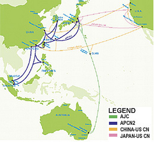
It's a quaint idea that there's an extensive network of submarine telecommunications cable spanning our oceans! See AJC and APCN2 in the map above!
Perhaps it's cruel to single out a tinpot tiddler like Faroese Telecom, the telco of the tiny Faroe Islands. However, the teensy telco claims to have laid several thousand kilometres of submarine fibre-optic cable. The cable apparently links the pint-sized islands to Denmark, Iceland and Scotland. And all to benefit a piffling 20,000 customers!
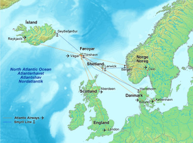
Where in the world are the (very well-connected) Faroe Islands?!
From: http://www.shefa.fo/
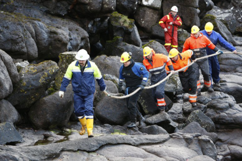
FAROESE SUBMARINE CABLE LAYERS: Heåve hø, låds!
-
whatsgoingon
- DELETED THEIR OWN POSTS :(
- Posts: 576
- Joined: Thu Oct 13, 2011 7:56 pm
Re: Satellites : general discussion and musings
a
Last edited by whatsgoingon on Fri May 24, 2013 10:31 am, edited 1 time in total.
Re: Satellites : general discussion and musings
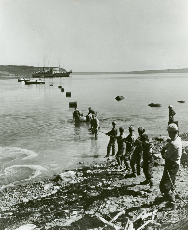
reichstag fireman wrote: Call me a voyeur, but I would love to watch a submarine cable getting laid!
It is quite simple - the cable is stored in the round hold and just pushed overboard at the stern, while the cable laying ship moves forward (on the right course). The Pirelli company long time ago asked me whether an Ukrainian built ship I knew could do it.
Down on the sea floor itself you can add a little machine to bury the cable in the mud, if you like. 100 years old technology starting with a cable Ireland/Canada laid on the Atlantic sea floor.
Last edited by Heiwa on Mon Oct 01, 2012 7:33 am, edited 1 time in total.
-
hoi.polloi
- Member
- Posts: 5060
- Joined: Sun Nov 14, 2010 7:24 pm
Re: Satellites : general discussion and musings
Wow. Wait a minute. How common are these sub-oceanic wires?
That would explain quite a lot. You can easily hide and bury submarine cables all over, and even connect them to vast distances safely - no need for bouncing anything. Do we know how extensive they are?
That would explain quite a lot. You can easily hide and bury submarine cables all over, and even connect them to vast distances safely - no need for bouncing anything. Do we know how extensive they are?
Re: Satellites : general discussion and musings
[st]http://www.telegeography.com/page_attac ... le-map.png[/st]
[EDIT: Screen shot of http://submarine-cable-map-2015.telegeography.com/ -HP]
From this page which has a link to launch a larger, more detailed map:
http://www.telegeography.com/telecom-re ... cable-map/
- cables_undersea.JPG (128.19 KiB) Viewed 7467 times
From this page which has a link to launch a larger, more detailed map:
http://www.telegeography.com/telecom-re ... cable-map/
Last edited by hoi.polloi on Thu Dec 21, 2017 7:58 pm, edited 1 time in total.
Reason: fix link
Reason: fix link
-
hoi.polloi
- Member
- Posts: 5060
- Joined: Sun Nov 14, 2010 7:24 pm
Re: Satellites : general discussion and musings
If we have such cables with direct connections between major population centers, what is the apparent point of beaming light all the way into outer space and back?

Another big strike against satellites, I suppose?
Another big strike against satellites, I suppose?
-
reichstag fireman
- Member
- Posts: 465
- Joined: Wed May 16, 2012 1:09 am
Re: Satellites : general discussion and musings
I love some of the related (vapourware) technology.Heiwa wrote:It is quite simple - the cable is stored in the round hold and just pushed overboard at the stern, while the cable laying ship moves forward (on the right course). The Pirelli company long time ago asked me whether an Ukrainian built ship I knew could do it.reichstag fireman wrote: Call me a voyeur, but I would love to watch a submarine cable getting laid!Down on the sea floor itself you can add a little machine to bury the cable in the mud, if you like. 100 years old technology starting with a cable Ireland/Canada laid on the Atlantic sea floor.
In the pioneering days of the 'transoceanic cable', glass thermionic valves were reportedly used to amplify the transoceanic signal. These valves were supposedly submerged in waterproof boxes at periodic points along the cable.
However they pulled it off, the pure joy of that smooth, mellow yet unpretentious sound of a valve amp must have made it all worth it!
From: http://gadgets.boingboing.net/2009/04/1 ... strat.html
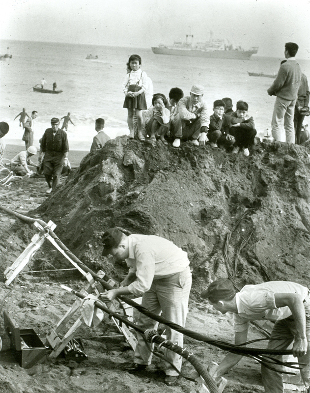
First Trans-Pacific submarine cable TPC1, laid 1964
First Trans-Atlantic submarine cable, TAT-1, laid 1955.
Capacity was apparently just 36 telephone calls at a time.
What a whole load of bother and cost! What was wrong with skywave communication? The authority on submarine cabling, BoingBoing (who?!) explains...
"Since trans-Atlantic service opened in 1927, calls had traveled across the ocean via radio waves. But cables provided much higher signal quality, avoided atmospheric interference and offered greater capacity and security."
Ahh! That'll be it then..
According to this Wired article, a 28,000 km submarine cable was laid in the mid-1990s. Described as "the longest wire on earth", it reportedly runs from England all the way to Japan! おやおや (Wow!)
From http://www.wired.com/wired/archive/4.12/ffglass.html

An absolutely incredible achievement, yet rarely if ever applauded (very modest those Brits). In fact, it seems that the Wired article is the first and only place the 28,000 km cable has ever gotten mentioned.
The question of 'splicing' such a vast length of cable is interesting. The manufacturing limit on an individual length of fibre optic cable is in the order of (low) tens of kilometres. So how is a submarine cable of thousands of kilometres reportedly joined? And whether the cable is electrical or optical, how is the signal regenerated over such enormous length? All communications cabling is prone to 'signal attenuation' which is directly proportional to the cable length.
Yet, somehow, the operators of "SHEFA-2", a fibre-optic cable apparently linking the Faroe Islands to Scotland, have overcome those physical limitations of attenuation. Limitations which have plagued fixed-wired telecommunications for 150 years.
According to wonkypedia, "SHEFA-2 is the world’s longest purely passive optical fibre cable link (390km), operated entirely without amplifiers". Another legendary feat for those tiny islands of Norsemen!
See: http://en.wikipedia.org/wiki/SHEFA-2
Yet when fibre optic cabling is laid on land, electrically-powered optical repeaters are needed every few tens of kilometres. Optical repeaters, being based on high-powered lasers, draw a large current and generate considerable heat. On land these repeaters have to be housed in special air-conditioned brick huts! Yet under the sea, especially the North Sea, repeaters are not needed at all?
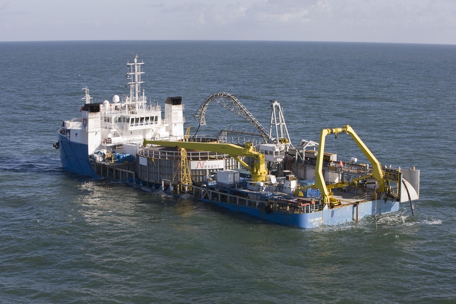
Cable length is interesting, for another reason. The bulk and weight of a huge length of cable (typical 40mm outside diameter, see ITU-T G.631) would be vast. What size and weight the cable reel?! Surely even a few hundred kms of cable would break the back of this poor old lady?!
From: http://globalmarinesystemsenergy.com/images/upload/File/Team_Oman_GMSL(2).pdf
and http://www.solasolv.com/images/team%20oman%20less.jpg
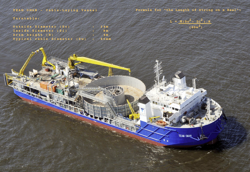
The 'cotton reel' formula came from http://mathforum.org/library/drmath/view/56488.html
Last edited by reichstag fireman on Wed Oct 03, 2012 9:10 pm, edited 2 times in total.
Re: Satellites : general discussion and musings
SZD0gcFbRl0
FNwiVWz52h0
"Space 'Harpoon' Tested In Search For Answer To Junk In Orbit"

[ADMIN: Original YouTube video removed; link replaced; new link also broken; give up? -HP Dec. 21, 2017]
FNwiVWz52h0
"Space 'Harpoon' Tested In Search For Answer To Junk In Orbit"
[ADMIN: Original YouTube video removed; link replaced; new link also broken; give up? -HP Dec. 21, 2017]
Re: Satellites : general discussion and musings
Funny how this thread is now discussing cables at the bottom of the sea.
My little involvement years ago was just about electric power transmission cables to connect various power grids so that Norway can export electric power to Europe (or vice versa). The communication cables seem to be laid at the bottom of the sea as a substitute to satellite communications or redundancy or being more secure or back up or simply better/cheaper or whatever. I see no fakery or hoax.")
[ADMIN: "substitite" changed to "substitute" - what you meant, I assume? -hp]
My little involvement years ago was just about electric power transmission cables to connect various power grids so that Norway can export electric power to Europe (or vice versa). The communication cables seem to be laid at the bottom of the sea as a substitute to satellite communications or redundancy or being more secure or back up or simply better/cheaper or whatever. I see no fakery or hoax.
[ADMIN: "substitite" changed to "substitute" - what you meant, I assume? -hp]
Re: Satellites : general discussion and musings
Why would they bother? At first glance this just sounds silly. What in the world route did they take?reichstag fireman wrote: Described as "the longest wire on earth", it reportedly runs from England all the way to Japan!