Hurricane Sandy

This is the forum dedicated to all 'minor' local psyops - phony murders, kidnappings and whatnot. It has now become evident that the news media constantly feeds the public with entirely fake stories - in order to keep us in eternal fear of our next-door neighbours and fellow citizens.
sunshine05
Member
Posts: 307
Joined: Mon Jan 28, 2013 6:00 pm

Hurricane Sandy

Unread post by sunshine05 »

I never took the time to look at the coverage of the hurricane until recently. Natural disasters are often overlooked when researching media fakery because no one really thinks to look for signs of fakery. We know there was a storm so everything that's reported must have really happened is the general thought. I believe they are over-exaggerating the extent of destruction in some cases. For example, there are outrageous stories of destruction to a pier in Seaside Heights, NJ. I'm not saying that a hurricane couldn't cause damage to a pier on a barrier island, but I want to post a few images and a video of a coaster and Ferris wheel that don't look right.

They claim that the pier fell apart, but the coaster and Ferris wheel are still standing upright, now in the sand.

Image


Image


There's a 3 minute CNN video with the coaster. Look at the :02 mark. I see a blurred line above the base of the coaster. The video looks like CGI to me. Then the interview with Harry Smith @ 1:06. He says "I'm like a 4th generation owner". Another interview @ 1:35 with Bob Stuart. He says "This building had been standing since the 1890's or something... and everything was gone"


full link: http://www.youtube.com/watch?v=CUleJ_NBirI

Finally, if you look at Bing maps "Seaside Heights", specifically near the pier area, when you're fairly zoomed out everything looks gray and desolate. No cars are around, buildings look run down. As soon as you zoom in all the way, everything is nice and bright and lots of cars, nice looking buildings. I'm seeing more and more indications of map manipulation. There is NO street view for Bing or Google available in this area. I don't really understand what's happening but I saw similar things with the Moore, OK tornado. In certain areas affected by the storm, the imagery changes drastically when you zoom further in.

Zoomed out
Image

Zoomed in
Image

Edit: It's Seaside Heights. I accidentally typed Seaview.
sunshine05
Member
Posts: 307
Joined: Mon Jan 28, 2013 6:00 pm

Re: Hurricane Sandy

Unread post by sunshine05 »

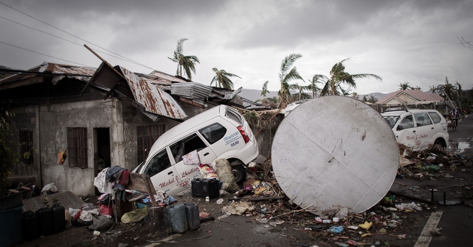
I noticed that the zoomed in, clear imagery is from a different company - Pictometry. They've been doing all of the aerial before/after imagery in the recent disasters, such as the OK tornado. I'm skeptical about this and believe they may be using aerial footage to manipulate the extent of damage in these disasters.

" We are getting a first hand look tonight at some Rochester-based technology that had a big role in assisting those devastated by tornadoes in Oklahoma. Pictometry showed us how the company's images helped first responders find victims. Not only did the technology we're about to show you help those first on the scene, it continues to help survivors of the tornado rebuild.

Pictometry's aerial oblique imagery combined with new technology called "rapid access" allows pictometry to take detailed pictures of property and buildings and turn those images around in just days. "That is invaluable for county, for 9-1-1 responders, for insurance companies who are trying to help their customers rebuild their properties and get back on their feet," said Chris Barrow, Pictometry CEO.

The Henrietta company has a fleet of 73 planes. It has captured about 90% of the country from the air so far.

"This is kinda like Google on steroids. Ya know, so first of all, when we cover an area, we cover it from border to border. If we're going to go fly in a particular county, we're going to take an image of that entire county. Every single property in that county, we're going to capture that. Store that in our database, so that no matter where there's an incident, after the fact, we'll have before images," said Barrow.

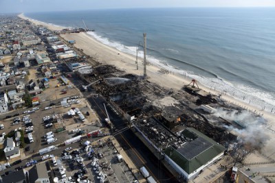
That was the case in Moore, Oklahoma. Pictometry already had pictures of the entire area that the path of the storm took in its library. When tragedy struck, planes were able to deploy to the same area again and recapture the devastation the storm left in its wake. "We were able to return back a very clear aerial perspective from multiple angles within a day of the storm. So within a very short period of time we were able to produce these amazingly accurate images," said Barrow.
In time of need, the pictures are priceless.

Pictometry recently merged with a Seattle-based company called Eagleview Technologies. Together they have 450 employees and most of the U.S. captured with aerial imagery.
- See more at: http://rochesterhomepage.net/fulltext?n ... 9KkCi.dpuf

http://www.pictometry.com/

Consider how easy it would be to take a deserted, non-inhabited area, show "before" imagery and then "after" imagery of damage. Collect federal grants for the damage...easy money.
Evil Edna
Banned
Posts: 117
Joined: Thu Nov 07, 2013 2:32 am

Re: Hurricane Sandy

Unread post by Evil Edna »

Found on faecesbook.com.

Image

The global warming hoaxers are using the fake rollercoaster images from Hurricane Sandy to promote their nonsense. The caption originally read Scientists Agree: CLIMATE CHANGE IS REAL.

The same clowns are today using the phony pics of Typhoon Haiyan to promote their climate change agenda all over again.

They fake the images of a natural disaster and then they insist their phony pics prove the #debateisover!!

Kerr-ching!
hoi.polloi
Member
Posts: 5060
Joined: Sun Nov 14, 2010 7:24 pm

Re: Hurricane Sandy

Unread post by hoi.polloi »

Interesting that you mention Rochester, I presume you mean the one in New York, not Minnesota? That location name seems to get involved in a lot of this PsyOp technology. I am not sure why I kept coming across 'Rochester' when trying to trace the vicsims back in 2009 but it kept coming up a lot. It's also associated with the John Titor hoax (don't get me started on that, please) and with Rockwell Collins.

I am guessing it is like a mini 'research triangle' or something. Very DOD/IBM feel to it. Lots of maudlin eagles and flags everywhere just driving through the creepy Minnesota one. The New York Rochester has a Rockwell Automation. As we've dug up, they are the ones that sort of were responsible for the hoaxing technology — both rockets and simulations — in the Apollo hoax.

Good find on the aerial photography research.
sunshine05
Member
Posts: 307
Joined: Mon Jan 28, 2013 6:00 pm

Re: Hurricane Sandy

Unread post by sunshine05 »

Yes, Pictometry is based in Rochester, NY. I believe there is wide scale image fakery occurring in Google and Bing maps associated with many of today's events. They simply publish before/after images to "prove" the natural disaster destruction occurred.

http://www.pictometry.com/
Evil Edna
Banned
Posts: 117
Joined: Thu Nov 07, 2013 2:32 am

Re: Hurricane Sandy

Unread post by Evil Edna »

Not strictly Hurricane Sandy, but in the same genre of PSYOP.

Our senses are lately overwhelmed by exaggerated / phony natural disasters.
First Storm St Jude then Typhoon Haiyan, and now the "devastating" mid-West Tornadoes!

This offering is from the Daily Mail, as ever, the class dunce for photoshop fails!

Image

Source:
http://www.dailymail.co.uk/news/article ... watch.html
Evil Edna
Banned
Posts: 117
Joined: Thu Nov 07, 2013 2:32 am

Typhoon Haiyan

Unread post by Evil Edna »

_
OXFAM and other NGOs are having a major fundraiser for victims of Typhoon Haiyan which apparently struck the Philippines in recent days. Over £33m (around US$50m) has been raised from generous benefactors, eager to help with the relief effort.

To raise awareness and funds, OXFAM is using graphic photo imagery of the disaster. That imagery includes photos taken by a Dennis M. Sabangan.

Image
An aerial view of the super typhoon devastated town of Guiuan, eastern Samar province, Philippines, 11 November 2013. Philippine authorities on 11 November, appealed for calm after one of the world's strongest typhoons left survivors desperate for food and water in areas affected by the storm: photo - EPA/DENNIS M. SABANGAN

A quick Google search discovers the following about Dennis Sabangan.
Dennis M. Sabangan
european pressphoto agency b.v.
Am Hauptbahnhof 16
60329 Frankfurt am Main
Germany

Dennis M. Sabangan is epa's chief photographer in Manila.

Before he joined epa in 2003 he worked as photographer for major Philippine newspapers. From 2006 until 2008 he also served as chairperson of the Philippine Center for Photojournalism. Dennis has covered such events as the 2004 Tsunami, the Myanmar Unrest, the US War Against Terrorism in Pakistan and Afghanistan, World Cup and Euro Cup soccer, the 2008 Olympics, and the Australian Open.
Mr Sabangan is well known for photographing natural disasters, including an apparent earthquake in Feb 2012.
Two of his images from that quake are attached below. They are odd to say the least.

Hmm. :unsure:

Image

Source:
http://www.epa.eu/about-epa-portfolios- ... m-sabangan
http://www.oxfam.org/en/emergencies/phi ... oon-haiyan
http://www.thenews.pl/1/10/Artykul/1525 ... oon-deaths
http://fotos.noticias.bol.uol.com.br/im ... fotoNav=31
http://photoblog.nbcnews.com/_news/2012 ... toll-rises
Last edited by Evil Edna on Tue Nov 19, 2013 4:30 am, edited 3 times in total.
anonjedi2
Member
Posts: 860
Joined: Mon Dec 31, 2012 5:50 am

Re: Hurricane Sandy

Unread post by anonjedi2 »

Well, the "Bridge Closed" sign is an obvious forgery/photoshop job and they didn't even bother to include it in the first photo? <_<
Evil Edna
Banned
Posts: 117
Joined: Thu Nov 07, 2013 2:32 am

Re: Hurricane Sandy

Unread post by Evil Edna »

Hi anonjedi2!

Which was first to use the road? The van or the bike? Must have been the bike first, and then the van got stranded!

The roadside on the right looks very different in the two photos. The roadside is very sloping in the second photo. Did it sink some more?
But the 5 M.T. sign stayed at the same angle. :blink:

One more from Mr Sabangan's quake:

Image
Last edited by Evil Edna on Tue Nov 19, 2013 5:51 am, edited 1 time in total.
Evil Edna
Banned
Posts: 117
Joined: Thu Nov 07, 2013 2:32 am

Typhoon Haiyan

Unread post by Evil Edna »

Here's another pretty dreadful effort for Typhoon Haiyan!

Image

The (undamaged) taxi seems to just melt into the ground / house!! :blink:

(Attributed to Philippe Lopez / AFP)

Source: http://noticias.uol.com.br/album/2013/1 ... otoNav=183
Evil Edna
Banned
Posts: 117
Joined: Thu Nov 07, 2013 2:32 am

Cyclone Cleopatra

Unread post by Evil Edna »

Evil Edna wrote:Our senses are lately overwhelmed by exaggerated / phony natural disasters.
First Storm St Jude then Typhoon Haiyan, and now the "devastating" mid-West Tornadoes!
And now Cyclone Cleopatra, a furious storm which has apparently struck Sardinia killing at least 20.

Photography / Footage of the cyclone is few and far between. Surprising for a developed nation, where private ownership of cameras and camera-phones must be high. Perhaps there's nothing to photo :rolleyes:

Here's one of the first pics to stumble across. It doesn't look too real.

Image

Source:

http://www.theage.com.au/world/sardinia ... 2xu5u.html
Cobra Commander
Member
Posts: 85
Joined: Sun Aug 03, 2014 5:45 am

Re: Hurricane Sandy

Unread post by Cobra Commander »

I had to chime in on this older thread because of my personal experience with the thread subject...

I'm a property claims adjuster, and I worked Hurricane Sandy, and the damage I had seen was nowhere near the MSM hype. There was real damage of course, but it was not the Superstorm they made it out to be. It seemed in this photo I had taken posted below from a roof I was inspecting, that they had one little block of damaged homes/buildings that may have been used for media photo ops to make it appear the whole area was flattened. This could have just been used as an area to dump damages, but I doubt it considering you would expect more garbage bags if this were clean-up debris from the town. Plus it was a terrible spot to dump debris. A one block landfill surrounded by houses and apartments? Notice there is not much damage to the apartments on the left of my pic from the Jersey shore (too early after storm for rebuilding and repairs)...

Image

Also, I track Hurricanes on Storm2K forums, and it also seemed strange that some storms that were not really deserving of a name got an official name from NOAA. Think about this, they had to get all the way to the S named storm that year, so maybe some of these tropical storms never really hit Tropical Storm status, and some of them may have just been Tropical Depressions. I know that models can latch on storms well in advance (Sort of La La Land science though), but maybe they anticipated having a storm named Sandy around the same time as Sandy Hook was planned by consistency in the top hurricane models showing a late season east coast storm. It was a strange experience, but they sent most of the independent adjusters home on 12-10-12 (4 days before Sandy Hoax) due to a mandate to close claims in a 30 day period, which caught all independent adjusters off guard. All adjusters I talked to there agreed this was very weird, and a first in their careers working canes. This was big news in New York, and New Jersey. Was this mandate used to keep pushing that name Sandy in peoples' minds, much like they use the word terror repeatedly, prepping them for the Sandy Hoax and so called coincidence in names?
sunshine05
Member
Posts: 307
Joined: Mon Jan 28, 2013 6:00 pm

Re: Hurricane Sandy

Unread post by sunshine05 »

Very interesting. Thank you, Cobra Commander. I've wondered about that area, particularly Seaside Heights. They filmed "Jersey Shore" there and I have a feeling this beach community was never anything more than a movie set. There are nothing but cheap, run down motels and the restaurants all seem fake. I did a search a while back for rentals in Seaside Heights on TripAdvisor and a condo/apartment was featured. It turned out that it was the apartment where Jersey Shore was filmed, the same exact unit.

About a year after the reported renovations of the boardwalk area, there was a fire that supposedly wiped out all of the restaurants and shops that looked fake to begin with. I think it's lots of insurance scams or something. It's really bizarre.

This is the same area where the roller coaster was upright in the ocean.

Image

http://mobile.nytimes.com/slideshow/100 ... m=nyregion

The fire broke out on Sept. 12, and burned more than four blocks of boardwalk in both Seaside Heights and Seaside Park. An investigation determined the fire started in wiring under the boardwalk in Seaside Park that had been damaged by exposure to storm water during Superstorm Sandy. The blaze started under a Kohr’s frozen custard stand and the Biscayne Candies shop and raged for eight hours, destroying about 50 businesses over several blocks. Among the other iconic venues that were damaged or destroyed in the fire were the Carousel Arcade, Jack & Bill’s, and Maruca’s Pizza.

http://newyork.cbslocal.com/2014/05/23/ ... fter-fire/
michiganj
Member
Posts: 83
Joined: Sat Dec 10, 2011 11:17 pm

Re: Hurricane Sandy

Unread post by michiganj »

Cobra Commander wrote:I had to chime in on this older thread because of my personal experience with the thread subject...

I'm a property claims adjuster, and I worked Hurricane Sandy, and the damage I had seen was nowhere near the MSM hype. There was real damage of course, but it was not the Superstorm they made it out to be. It seemed in this photo I had taken posted below from a roof I was inspecting, that they had one little block of damaged homes/buildings that may have been used for media photo ops to make it appear the whole area was flattened. This could have just been used as an area to dump damages, but I doubt it considering you would expect more garbage bags if this were clean-up debris from the town. Plus it was a terrible spot to dump debris. A one block landfill surrounded by houses and apartments? Notice there is not much damage to the apartments on the left of my pic from the Jersey shore (too early after storm for rebuilding and repairs)...

Image

Also, I track Hurricanes on Storm2K forums, and it also seemed strange that some storms that were not really deserving of a name got an official name from NOAA. Think about this, they had to get all the way to the S named storm that year, so maybe some of these tropical storms never really hit Tropical Storm status, and some of them may have just been Tropical Depressions. I know that models can latch on storms well in advance (Sort of La La Land science though), but maybe they anticipated having a storm named Sandy around the same time as Sandy Hook was planned by consistency in the top hurricane models showing a late season east coast storm. It was a strange experience, but they sent most of the independent adjusters home on 12-10-12 (4 days before Sandy Hoax) due to a mandate to close claims in a 30 day period, which caught all independent adjusters off guard. All adjusters I talked to there agreed this was very weird, and a first in their careers working canes. This was big news in New York, and New Jersey. Was this mandate used to keep pushing that name Sandy in peoples' minds, much like they use the word terror repeatedly, prepping them for the Sandy Hoax and so called coincidence in names?

Dear Cobra, I'm curious as to why you re-sized and cropped this image that you say you took yourself from a nearby rooftop. Today's megapixel cameras are capable of taking much larger photos. The hosting site postimg.org allows images up to 1600x1200 pixels. Do you have an original larger and wider photo that you could share?

Thanks
hoi.polloi
Member
Posts: 5060
Joined: Sun Nov 14, 2010 7:24 pm

Re: Hurricane Sandy

Unread post by hoi.polloi »

That's a good question. Perhaps you can answer why you deleted your own posts in these threads, michiganj:

http://cluesforum.info/viewtopic.php?f= ... 9#p2374949
http://cluesforum.info/viewtopic.php?f= ... 6#p2376086

(This discussion will be moved to the derailing thread if it is not addressed here in the next post.)
Post Reply